Most people think of lidar mapping as a planning tool. Engineers use it. Developers use it. Surveyors rely on it. However, something important is changing in 2026. Cities and public agencies now use lidar mapping for enforcement.
Instead of waiting for complaints, inspectors can scan land from above. Instead of relying on photos, they collect measurable terrain data. And instead of guessing what changed, they compare scans and prove it.
That shift matters more than most property owners realize.
The Big Change: From Site Visits to Smart Oversight
In the past, enforcement required boots on the ground. An inspector had to visit the site, take photos, and write notes. That process took time. It also left room for debate.
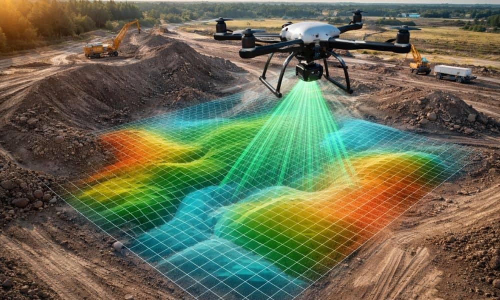
Now, many agencies use drones equipped with laser sensors. These systems capture detailed elevation data across large areas in a short time. As a result, cities can monitor sites faster and more often.
This does not mean someone watches every project daily. However, it does mean that technology allows cities to check land conditions without waiting for a call.
That is where lidar mapping enters the picture.
Why Photos Are No Longer Enough
A photo shows what something looks like. But it does not measure how high a pile of dirt stands. It does not calculate how much soil moved. It cannot confirm whether a slope changed by six inches or two feet.
On the other hand, lidar mapping collects elevation data point by point. That means agencies can measure volumes of material, verify grade changes, detect surface shifts, and compare before-and-after conditions.
Because of that, disputes become harder to argue. If a scan shows that five feet of fill appeared inside a restricted area, the numbers speak clearly.
In enforcement cases, numbers matter more than pictures.
Where Lidar Mapping Is Being Used for Oversight
You might wonder what this looks like in real life. In 2026, agencies will use lidar mapping in several key areas.
Illegal dumping creates serious problems on vacant land. With lidar mapping, officials measure the volume of debris and rescan the site later to confirm removal. Therefore, cleanup orders carry more weight.
Unauthorized grading also draws attention. Even small changes can affect drainage or neighboring properties. With lidar mapping, inspectors compare current terrain against approved plans. If elevations do not match, the data shows it clearly.
Floodplain violations require strict elevation control. A few inches of extra fill can change how water flows. Instead of guessing, agencies scan the area and verify ground height precisely.
Environmental buffer disturbances trigger disputes as well. Tree removal and land clearing inside protected areas often spark complaints. Lidar mapping detects terrain change even when vegetation hides the ground. As a result, cities gain stronger proof in enforcement actions.
Each example shows the same pattern. Measurement replaces opinion.
What This Means for Developers and Property Owners
At first, this shift might feel uncomfortable. However, it also creates opportunity.
Today, cities can respond to complaints faster. They collect terrain data without long delays. They confirm site conditions with precision.
Because of that, developers must think differently about risk.
For example, imagine a neighbor claiming your grading redirected stormwater onto their lot. In the past, both sides might argue about photos. Now, lidar mapping shows exact elevation changes and flow direction.
Similarly, if someone accuses you of filling inside a setback line, measurable terrain data supports or refutes that claim.
In short, enforcement grows more data-driven. Therefore, protection must also become data-driven.
The Dallas and North Texas Factor
North Texas continues to grow fast. New subdivisions expand outward. Commercial sites replace open land. Infrastructure projects reshape large tracts.
With that growth comes more oversight.
Cities want to protect drainage systems. They want to prevent illegal dumping. They want to ensure grading follows approved plans. As development spreads into previously rural areas, monitoring becomes harder from the ground.
However, lidar mapping solves that challenge. Agencies scan broad areas efficiently. They review conditions after storms. They compare terrain over time.
For developers in Dallas and surrounding cities, this means terrain data will likely play a larger role in compliance discussions moving forward.
The Proactive Advantage
Now here is the important part.
You do not need to wait for enforcement to use lidar mapping.
In fact, smart developers already use it before inspections happen. Before major grading begins, they bring in lidar mapping experts to document the existing terrain. That way, they know exactly what the site looked like before any equipment ever touched the ground.
Then, as work moves forward, they verify elevations before requesting final approval. After heavy storms, they rescan to confirm nothing shifted unexpectedly. If subcontractors reshape an area, they check that the finished grades match the approved plans.
Because of that, they are not left scrambling if someone raises a concern later.
They already have a clear, measurable record of site conditions.
So if a dispute arises, the conversation changes immediately. Instead of arguing over opinions or photos, they rely on precise terrain data.
In other words, they do not react to enforcement. They stay ahead of it.
Why 2026 Marks a Turning Point
Several trends push lidar mapping into enforcement roles this year.
First, drone technology has become more accessible. Agencies deploy internal teams without massive budgets.
Second, processing software works faster than ever. What once took weeks now takes days.
Third, public expectations around environmental protection and compliance continue to rise. Communities want accountability.
As these factors combine, lidar mapping moves beyond planning and into oversight.
This does not mean every project faces constant scanning. However, terrain data will increasingly shape compliance decisions.
Accountability From Above
Lidar mapping no longer sits quietly in the engineering toolbox. It now supports accountability.
Cities use it to measure illegal dumping. They use it to verify grading. They use it to monitor floodplain activity. And they rely on it because numbers reduce debate.
For developers and landowners, this shift brings both responsibility and protection.
When you understand how lidar mapping works in enforcement settings, you prepare. You document conditions. You reduce risk before problems grow.
In 2026, the land tells a measurable story.
The question is simple: will you let someone else capture that story first, or will you use lidar mapping to protect your own project?