Most people never look at zoning maps. They sit quietly in planning files and city websites for years. Then one boundary shifts — and suddenly, certain parcels become very attractive. A property that once had tight limits may now allow more units, different uses, or larger buildings. As a result, interest spikes fast. When that happens, developers don’t wait around. Instead, they move quickly to understand the land before they invest money or submit plans. That’s why one of their first moves is ordering a topographic survey.
Why Map Changes Create Urgency for Real Ground Data
A zoning update changes what you can build. However, it doesn’t change the land itself. The slopes, low spots, and drainage paths stay exactly where they were. Because of that, developers need to check whether the newly allowed project actually fits the site.
At the same time, zoning shifts often attract multiple buyers. Competition grows. Decisions must happen faster. Yet nobody wants to rush into the wrong deal. So instead of guessing from aerial images, teams order a topographic survey to see true site conditions.
That survey replaces assumptions with measurements. Consequently, early decisions become more reliable.
What a Topographic Survey Shows That Maps Don’t
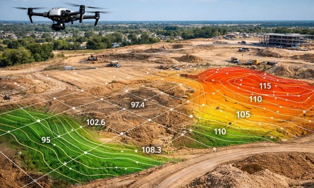
A zoning map shows allowed use and density. A topographic survey shows how the ground behaves. That difference matters more than most people expect.
Topo data captures elevation points across the property and turns them into contours. Those contours reveal slopes, high areas, low pockets, and drainage flow. In addition, the survey maps visible features like pavement, structures, and surface improvements.
From the street, many sites look flat. However, topo data often tells a different story. A one-foot drop across a building pad can change foundation cost. A shallow basin can create water problems. A hidden slope can affect driveway design. Because of this, developers want topo results early — not halfway through design.
Faster Feasibility Decisions Start With a Topographic Survey
When zoning lines move, feasibility becomes the big question. Can the project work here? Will costs stay reasonable? Will permits move smoothly?
Those answers depend heavily on the ground surface. For example, steep slopes increase grading work. Uneven terrain affects layout efficiency. Drainage paths influence stormwater design. Therefore, a topographic survey becomes the base layer for every serious feasibility study.
With good topo data, engineers and planners test layouts quickly. They adjust building positions. They spot constraints early. As a result, weak sites get rejected fast, and strong sites move forward with confidence.
That speed gives developers a real edge in competitive areas.
Flood and Drainage Concerns Increase the Pressure
In many growing regions, zoning discussions connect closely with flood risk and drainage control. When development expands, runoff patterns change. More roofs and pavement push more water across the land. Because of that, elevation details matter even more.
A topographic survey helps design teams see where water will collect and where it will flow. That insight supports smarter grading and stormwater plans. It also prevents late surprises that can delay permits or raise construction costs.
Moreover, lenders and reviewers often look closely at sites with flood exposure. Solid elevation data builds trust in the design. Therefore, developers who expect scrutiny don’t delay topo work — they prioritize it.
Design Teams Cannot Work From Guesswork
Architects can sketch ideas without detailed ground data. However, engineers cannot finalize site design that way. Grading plans, drainage layouts, and access slopes all depend on measured elevations.
Without a topographic survey, design teams make rough assumptions. Later, when real data arrives, plans change. That leads to redraws, extra fees, and timeline slips. On the other hand, when topo data comes first, design flows forward instead of backward.
Contractors also depend on that accuracy. Earthwork pricing, cut-and-fill balance, and retaining needs all come from elevation models. Therefore, topo data supports not only design quality but also cost control.
This Rush Isn’t Only About Big Developers
Large development firms order topo surveys regularly. Still, smaller property owners also feel the impact when zoning lines move. A parcel that gains new building rights suddenly supports additions, splits, or multi-unit plans.
In those cases, owners face the same core question: will the land support the idea? A topographic survey gives a clear answer. It shows usable areas, slope limits, and grading needs. Because of that, even mid-size projects benefit from early topo work.
Homeowners planning major site changes — like large additions or re-grading — also gain value from topo data. Better information leads to better decisions at every scale.
Early Topo Work Saves Time Later
Some people assume surveys slow projects down. In reality, skipping early topo work causes more delay. When elevation data arrives late, designers redo plans. Permit reviewers request revisions. Budgets shift. Meanwhile, schedules stretch.
By contrast, when teams start with a topographic survey, fewer surprises appear later. Plans align with real ground conditions from day one. Reviews move faster. Cost estimates hold steadier. As a result, the project timeline stays healthier.
So while the field survey takes time, it protects the overall schedule.
When Zoning Lines Move, Smart Teams Measure First
Zoning boundaries will keep changing as cities grow and policies adjust. Each change creates new chances — and new risks. Paper rules can open doors, but only ground data shows whether a project truly works.
That’s why developers react so quickly. They don’t rely on hope or rough visuals. Instead, they order a topographic survey and study the land as it really is.
Because in the end, the map may change — but the ground tells the truth.